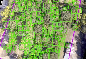
Drones provide significant benefits in forestry by utilizing advanced technology to count trees through high-resolution imagery.
This technology and data can be vital for foresters, loggers, and real estate agents.
Forestry
Services We Provide:
- High-resolution imagery depicting tree count ,tree mass sizes, and additional data.
- Georeferencing and aligning the plane of the the high quality images.
- Identify trees located along the property lines that may avoid lawsuits from adjacent land owners.
- Identifying dead and threating trees on your property.
- Provides shape file of data and imagery to customer or any other format requested.
- Help the customer optimize the use of data in their current or developing GIS system.
GIS Data with tree count and tree area size below.