Why use Drones in utilites?
Drones offer detailed images of remote locations, allowing more people to observe these areas. They collect data more quickly than a person can traverse the area, without disrupting the customer.
RCS Imaging supports utility companies in many various capacities.
- Exposing Leaks
- Storm Damage
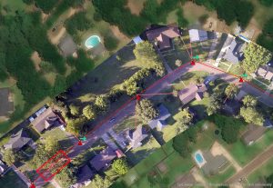
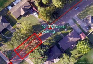
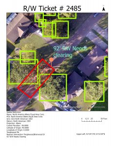
- Right of Way and Line Inpections
- Update exisitng and Building New GIS systems
- Providing real time field data to clients
- Inventory
- Tree inspections along right of ways
- Utility ticket systems
- Tank inspections
Electric Power Grids
Features:
- Identifies potential threats to power lines by identifying trees along the right of way
- High-resolution imagery of power lines and poles provides real-time information about the exact conditions at any given location.
- Create Right of Way Trim tickets with your existing ticket application or our advanced Ticket system.
- Identify what poles have street lights, transformers and other devices on the poles.
- Estimate the cost of tree trimming based on the number of trees and the size of the area that requires trimming
- There is no inconvenience for the customer, and it is effortless to access hard-to-reach areas.
Services We Provide:
- High-resolution imagery depicting power lines ,service lines, and additional data.
- Georeferencing and aligning the plane of the the high quality images.
- Identify trees located along the right of way and trees that may potentially endanger service lines.
- Identify areas that need to be trimmed and generate tickets based on threat.
- Provides shape file of data and imagery to customer or any other format requested.
- Help the customer optimize the use of data in their current or developing GIS system.
Check out our brief video to discover how we can assist your utility service today.
GIS Data and Ticket Generation Examples below