Small towns and rural waterworks often face unique challenges in managing aging infrastructure, limited budgets, and outdated record-keeping systems. In an era where efficiency and sustainability are critical, leveraging modern technology like Geographic Information Systems (GIS) can transform how communities manage water utilities. This blog explores how integrating historical data—such as 1966 paper maps and preliminary plats—into a dynamic, hosted GIS map can empower small towns to optimize operations, reduce costs, and improve service reliability.
The Challenge: Outdated Infrastructure Records
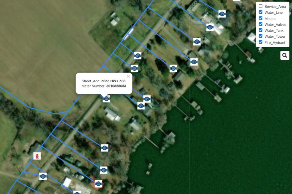
Many small towns rely on decades-old paper maps and plats to manage water distribution systems. These fragile documents, while historically valuable, are prone to deterioration, difficult to update, and inefficient for real-time decision-making. For example, a small southern town in Louisiana town approached our team with a collection of 1966 paper maps and preliminary plats that were their sole reference for locating water mains, meters, fire hydrants, valves, and service lines. Their goal was to modernize their system without losing the legacy data embedded in these records.
The Solution: Digitizing History with GIS
To bridge the gap between analog and digital, we developed a three-step process to convert their 1966 paper maps into a hosted, interactive GIS platform:
1. Scanning and Georeferencing
- Digitization: High-resolution scanners were used to create digital copies of the original paper maps and plats. This preserved the integrity of the hand-drawn details, including pipe diameters, valve locations, and elevation markers.
- Georeferencing: Using GIS software (ESRI ArcGIS), we aligned the scanned maps with real-world coordinates. Control points (e.g., road intersections, landmarks) were identified on both the scanned images and modern satellite imagery to ensure spatial accuracy.
2. Data Extraction and Layer Creation
- Vectorization: Key features (pipes, hydrants, valves) were traced and converted into vector layers, creating a structured dataset.
- Attribute Assignment: Metadata from the 1966 maps (e.g., pipe material, installation dates) was entered into the GIS database, enabling query-based analysis.
- Integration with Modern Data: Preliminary plats were cross-referenced with current parcel maps to identify discrepancies and update service line connections.
3. Gathering Field Data
- Employees in the field: This small utility utilized meter readers to gather field data, facilitating meter locations, ensuring all meters were accounted for, and generating cost savings for the utility.
- RCS Imaging gathering data : While we offer our GIS data gathering service, we encourage the utility companys to take part in the GIS data gathering service to help them save costs.
4. Hosting and Accessibility
- Cloud-Based GIS Platform: The finalized layers were uploaded to a hosted GIS service (RCS Imaging Host), creating an interactive web map accessible to town staff via any device.
- RCS Imaging Host Cost Savings: By partnering with RCS Imaging, the utility can avoid costly GIS software and hosting fees, while benefiting from regular updates either from RCS Imaging or their utility company..
- User Permissions: Customizable access levels ensured that field crews, engineers, and administrators could view or edit data based on their roles.
Benefits for Small Towns
- Cost Efficiency: Eliminates the need for costly manual updates; changes are reflected in real time. Town would not need to hire a GIS tech or purchase any software as RCS Imaging handled all the GIS and host interactive maps for the Town/Waterworks company.
- Emergency Response: Field crews can quickly locate valves and mains during leaks or breaks using mobile devices. Fire Trucks could locate Fire Hydrants 80% faster utilizing GIS maps. Allows utilities to implement outage management strategies in the future..
- Long-Term Planning: Historical data combined with modern analytics helps prioritize infrastructure upgrades.
- Public Transparency: Shareable maps improve community engagement by visualizing water system investments.
Overcoming Challenges
- Legibility Issues: Faded ink and handwritten notes required careful interpretation and collaboration with local historians.
- Data Gaps: Missing details in the 1966 maps were supplemented by ground-penetrating radar (GPR) surveys and interviews with retired utility staff.
- Training: We provided workshops to ensure town employees could navigate the GIS platform confidently. Managers and certain field technicians received training on data collection for map updates.
Case Study: A Success Story
After implementing the hosted GIS map, the town reported:
- A 40% or greater reduction in repair time during water main breaks.
- Improved accuracy in grant applications for infrastructure funding.
- Enhanced collaboration between water departments and local contractors.
- Provided the site with an updated map of their service area and a web based map of their utilitys that can be accessed anywhere and anytime.
- Fire hydrant locations were updated, and tablets were installed in fire trucks for easy access to the nearest hydrants in emergency situations.
Conclusion: Bridging Past and Future
For small towns, modernizing water utilities doesn’t mean discarding historical records—it means unlocking their value through technology. By transforming 1966 paper maps into a dynamic GIS platform, communities gain a powerful tool to manage resources sustainably, respond to crises, and plan for growth.
Call to Action
Is your town, waterworks, or other utilitys struggling with outdated system records? Let’s discuss how GIS can turn your historical data into a roadmap for the future. We offer multiple cost saving ways to gather the data needed to get your infastructure on the right path. Contact us today for a free consultation.
Take a look at our Interactive Demo site the team has created.
About the Author
Racky Book is a GIS specialist with 15 years of experience in GIS integration and infrastructure modernization for small towns and utilites.
Awesome write up, I contacted you about some services for us.